Page, Arizona (Glen Canyon National Recreation Area), United States
Horseshoe Bend, Arizona
A tight bend of the Colorado River, a short hardened path and the canyon country around Page
- 1.5 miles (2.4 km)Round-trip walk to the overlook
- Roughly 1,000 ft (305 m)Depth of the bend
- About 4 miles (6 km)Distance southwest of Page
Horseshoe Bend at a glance
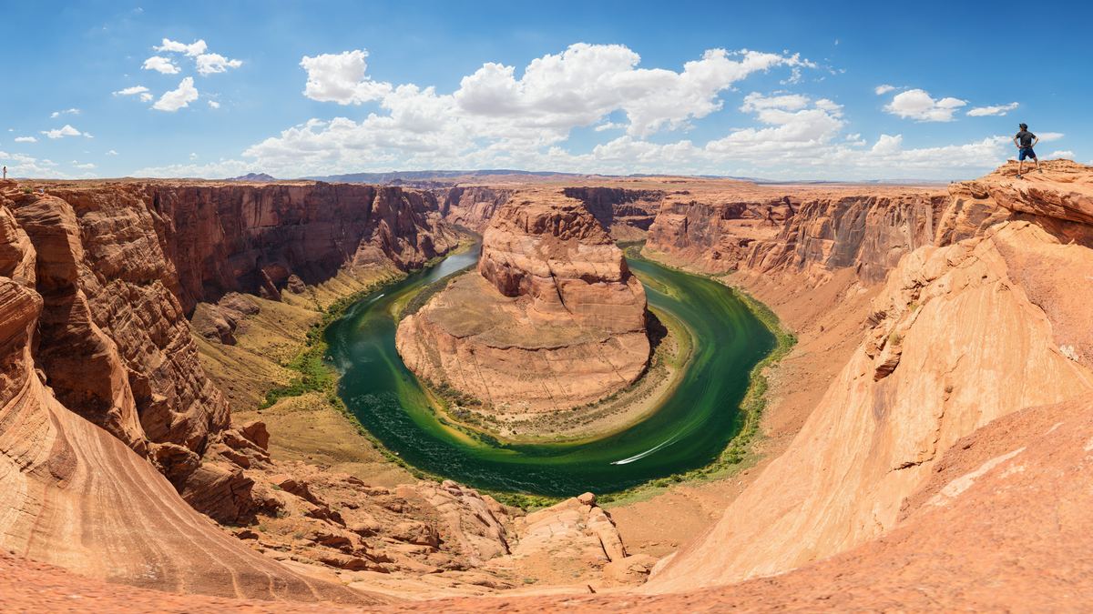
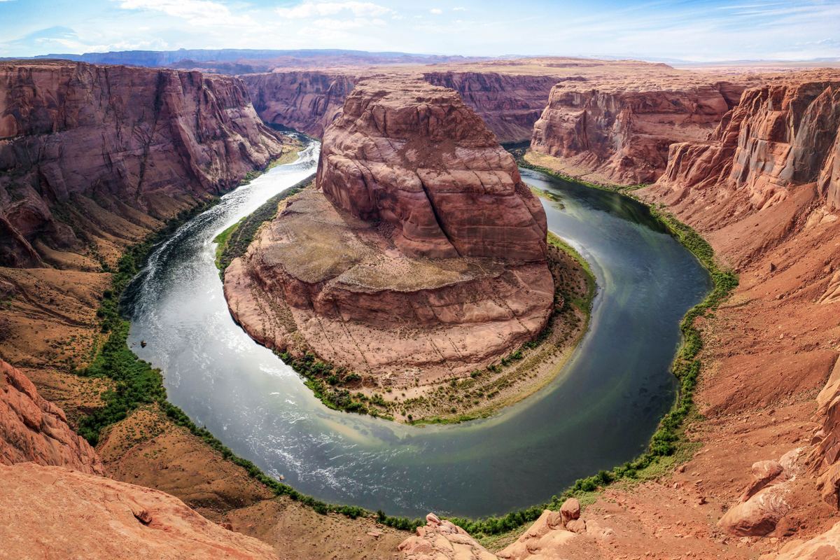
At this spot the river cut a bend roughly 1,000 ft (305 m) deep, shaping a 270-degree curve through Glen Canyon. The bend and that reach of the river belong to Glen Canyon National Recreation Area. From Page the bend lies about 4 miles (6 km) to the southwest, and the overlook stands 4,200 feet (1,300 m) above sea level.
Why visit
Looking over the rim, visitors face a drop of about 1,000 feet (300 m) to the Colorado River. Grand Canyon National Park begins about nine miles downstream of the bend, and Horseshoe Bend itself is about 5 miles (8 km) downstream from Glen Canyon Dam and Lake Powell. Until the dam was built in the 1960s and Lake Powell was created, the central Colorado Plateau and Glen Canyon were mostly inaccessible. Guided services in the surrounding Glen Canyon area now include raft floats, Lake Powell boat tours and guided hikes.
Distances around the bend
Several reference points place the bend on the map. Off US Highway 89, roughly 5 miles (8 km) south of the Carl Hayden Visitor Center, lie the parking lot and trailhead.
| Reference point | Distance and direction |
|---|---|
| Town of Page | About 4 miles (6 km) to the southwest |
| Glen Canyon Dam and Lake Powell | The bend is about 5 miles (8 km) downstream |
| Carl Hayden Visitor Center | Trailhead and parking lot roughly 5 miles (8 km) to the south, reached from US Highway 89 |
| Grand Canyon National Park | Begins about nine miles downstream of the bend |
| Elevation | The overlook is 4,200 feet (1,300 m) above sea level |
Land and management
The trail and the overlook, like all the land south of the parking area, are on the Navajo Nation. The overlook is inside Glen Canyon National Recreation Area, while the lot where the walk begins is located in the City of Page. Glen Canyon National Recreation Area contains four National Register listed properties.
The walk to the overlook
A hardened path, 1.5 miles (2.4 km) there and back, links the parking area with the overlook. Under the regulations of the Architectural Barriers Act, the path to the overlook counts as accessible. Sunrise to sunset marks the open hours for both the lot and the overlook. The bend below is roughly 1,000 ft (305 m) deep, with a 270-degree horseshoe-shaped curve.
Conditions along the trail
- Shade: two shade structures stand along the trail, none at the overlook, and there is very little shade overall.
- Water: no drinking water is supplied along the trail, and visitors bring their own.
- Toilets: there are none along the trail; the toilets are in the parking lot.
- Railings: the viewing platform at the overlook has railings, none run along the trail, and much of the rim is exposed to the 1,000-foot drop.
Parking and fees
As of 2025, the City of Page charges $10 per passenger car at the Horseshoe Bend lot. The lot is on city land and run by the City of Page, and America the Beautiful and other National Park Service passes do not cover it.
Tours and activities
Several guided formats run in the Glen Canyon area. Antelope Canyon can only be visited on a guided tour, and a guided tour of Glen Canyon Dam descends through the dam to the generator room. The activities below list tours available around Horseshoe Bend.
Tours around Horseshoe Bend
On the water
A Colorado River raft float from Glen Canyon Dam to Lees Ferry takes about 3 hours, and the raft operator also provides backhaul service for private paddlecraft.
Guided services in Glen Canyon
Grand Canyon North Rim, a nearby day trip from Page, has cooler temperatures and fewer people than the South Rim.
When to go
Precipitation around Page is bimodal, with a late summer to early fall peak and a late winter peak. Most precipitation near Page falls as rain, but winter storms occasionally bring snow, especially at higher elevations in the area. From November to May, storms reach the Glen Canyon area from the Pacific Ocean.
| Activity | Jan | Feb | Mar | Apr | May | Jun | Jul | Aug | Sep | Oct | Nov | Dec |
|---|---|---|---|---|---|---|---|---|---|---|---|---|
| Pacific storms reach the Glen Canyon area | JanRuns | FebRuns | MarRuns | AprRuns | MayRuns | Not listed | Not listed | Not listed | Not listed | Not listed | NovRuns | DecRuns |
| Arizona monsoon | Not listed | Not listed | Not listed | Not listed | Not listed | Not listed | JulRuns | AugRuns | SepRuns | Not listed | Not listed | Not listed |
- Runs
Keep exploring
Storms and flash floods
From July to September, Arizona's monsoon sends storms moving northwest out of Mexico. Summer thunderstorms at the Grand Canyon cluster mainly from 11 a.m. until 6 p.m., and the frequent months for them are July, August and early September. Water in canyons can rise quickly downstream from heavy rain even when the parent thunderstorm is miles away, and hikers in Glen Canyon region slot canyons have been killed by flash floods generated by thunderstorms as far as 25 miles away. Flash flooding can occur at any low water crossing or dip, including on roads, and flooded roadways are not to be entered. After the last clap of thunder, the waiting period before going back outside is at least 30 minutes.
How to get there
US Route 89, which runs predominantly north-south, is the main road into Page, and the trailhead parking area is just off that route in southwestern Page. It has a lighted, paved runway 5,500 feet long, and it carries a Class III designation and is currently limited to 30 passengers per aircraft. To reach the Grand Canyon South Rim's Desert View East Entrance from Page, the route takes Highway 89 south to Cameron, then Highway 64 west.
Keep exploring
Where to stay
At Bullfrog Marina there is a lodge, housekeeping units and 2 campgrounds, one with hook-ups.
Keep exploring
Camping in Glen Canyon
- Lone Rock is a primitive campground located between Greenhaven, Arizona and Big Water, Utah, and camping at Lone Rock Beach costs $10 per vehicle with no hookups.
- Campgrounds operated by the National Park Service in Glen Canyon have no reservation system and no phone numbers, whereas campsites at concessioner-operated campgrounds in the recreation area are booked through the concessioner.
Landscape and geology
Uplift in the region began between six and five million years ago, and the river then cut down rapidly to form the bend. Sandstone in the Glen Canyon area was created by ancient sand dunes of Jurassic deserts and preserves dinosaur tracks. Theropod dinosaur tracks are found in the Wingate Sandstone, Kayenta Formation and Navajo Sandstone of the Glen Canyon area.
Wildlife of Glen Canyon
Birds
Just 80 native bird species have been confirmed breeding in Glen Canyon National Recreation Area, where the setting includes harsh climate, bare slickrock and cliffs, and low desert shrub vegetation. Habitat destruction, lead poisoning and poaching reduced the California condor population to 22 birds in 1982, and condors were reintroduced to the Glen Canyon area in 1996, with six captive parent-reared birds released at the Vermilion Cliffs on the Paria Plateau.
Mammals
Desert bighorn sheep in Glen Canyon National Recreation Area were reestablished from herds in the Escalante and Canyonlands areas after westwide declines in the 1800s.
Guides
Guides to Horseshoe Bend and Glen Canyon
Questions about Horseshoe Bend
What is the length of the overlook hike?
The round trip over a hardened path totals 1.5 miles (2.4 km) from the parking area to the overlook and back.
What does parking cost, and do national park passes apply?
As of 2025 the City of Page charges $10 per passenger car. The lot is on city land and run by the city, and America the Beautiful and other National Park Service passes do not cover it.
Which tours run in the Glen Canyon area?
Antelope Canyon can only be visited on a guided tour, and a guided tour of Glen Canyon Dam descends through the dam to the generator room. Smooth water float trips run on the Colorado River from Lees Ferry to Horseshoe Bend and back. Multiple Lake Powell boat tours depart from Wahweap Marina, and charter tours operate from Halls Crossing.
When do monsoon storms arrive?
Arizona's monsoon spans July to September, with storms moving northwest out of Mexico. In the Grand Canyon, summer thunderstorms occur mainly from 11 a.m. to 6 p.m., and July, August and early September see them often.
What is the distance between Page and the bend?
The bend lies about 4 miles (6 km) to the southwest of the town of Page. Trailhead parking sits about 5 miles (8 km) south of the Carl Hayden Visitor Center, off US Highway 89.
Is there water, shade or a toilet along the trail?
No drinking water is supplied along the trail. Two shade structures stand along it and none at the overlook, and there are no toilets on the trail itself; the toilets are in the parking lot.
How are campsites booked in the recreation area?
National Park Service campgrounds in Glen Canyon take no reservations and list no phone numbers. Concessioner-operated campgrounds are booked through the concessioner, and camping at Lone Rock Beach costs $10 per vehicle.
Browse tours around Horseshoe Bend
See toursSources
- Horseshoe Bend - Glen Canyon National Recreation Area (U.S. National Park Service)
- Horseshoe Bend on the Colorado River (U.S. National Park Service)
- Horseshoe Bend (Arizona)
- Mesozoic Fossils - Glen Canyon National Recreation Area (U.S. National Park Service)
- Guided Tours - Glen Canyon National Recreation Area (U.S. National Park Service)
- Take a stroll to Horseshoe Bend Overlook (U.S. National Park Service)
- Fees & Passes - Glen Canyon National Recreation Area (U.S. National Park Service)
- Page, Arizona
- Park Statistics - Glen Canyon National Recreation Area (U.S. National Park Service)
- Page
- Climate Change - Glen Canyon National Recreation Area (U.S. National Park Service)
- Weather and Climate - Grand Canyon National Park (U.S. National Park Service)
- Monsoon Season (U.S. National Park Service)
- Weather Dangers - Grand Canyon National Park (U.S. National Park Service)
- About - City of Page
- COUNCIL RECOMMENDS CONTOUR AIRLINES FOR CONTINUED AIR SERVICE AT PAGE MUNICIPAL AIRPORT - City of Page
- How Do I Travel to the South Rim ? - Grand Canyon National Park (U.S. National Park Service)
- Lake Powell Marinas - Glen Canyon National Recreation Area (U.S. National Park Service)
- Eating & Sleeping - Glen Canyon National Recreation Area (U.S. National Park Service)
- Increasing Recreational Access to Lake Powell - Glen Canyon National Recreation Area (U.S. National Park Service)
- Camping - Glen Canyon National Recreation Area (U.S. National Park Service)
- Mammals - Glen Canyon National Recreation Area (U.S. National Park Service)
- Birds - Glen Canyon National Recreation Area (U.S. National Park Service)
- Condors - Glen Canyon National Recreation Area (U.S. National Park Service)